Well, the festivities and celebrations for the new year are over ultimately. So the first post of 2017 on Fully Editable Countries of the World PPTx Vector Freeform Map. The super cool features of this PPTx map bundle are:-
- Fully editable vector freeforms for each country and independent region of the world, do all the styling from the Presentation software itself
- Selection of any country freeform by name from Selection Pane or just click on the country polygon on the slide itself
- Regions and small countries, not seen on other maps or presentation slides, can be easily selected from the alphabetically arranged country names in the selection pane
- 16:9 and 4:3 mode Presentations
- Meticulously adjusted Free continent maps slide for mix and match maps
- High accuracy of representation, zoom to 500 percent or show individual countries on a single slide
- Select every country by single click even when made up of hundreds of freeforms like Canada
- Import in Excel or Word with all country names intact in selection pane
- Best for sales, academic, marketing and supply chain management presentations
Selection of Countries by its Name From Freeform Selection Pane. This single feature in the map slides makes it so easy to use that any country freeform can be stylized by point and click of a mouse. We have painstakingly labeled each country and independent region in the selection pane, spending tens of hours on accurately selecting each freeform. You can select Antigua and Barbuda or Dhekelia Sovereign Base Area or Heard and McDonald Islands, all arranged alphabetically for easy selection. As an example you can see the freeform of Argentina selected from the Selection and Visibility pane.

The next feature is the 16:9 and 4:3 presentation modes. Yes, in the bundle you get both presentation modes, thereby saving your hours of effort in resizing and adjusting slides. You can choose to purchase single presentation mode also it is highly recommended that you purchase both the presentations, and you will not regret it.


The third feature is free slide of continents with names. And yes all these slides are meticulously adjusted to sit exactly on top of each other, so just do the mix n match.

The names slides, the country slide on continents and you can make any number of maps with them. This feature gives you the flexibility and control on making hundreds of map designs for your presentations.
The fourth feature is the accuracy of representation. The countries are drawn with highest accuracy that even zooming to 300 or 400 percent does not cause any loss of fidelity. So if you select Cuba and zoom it to 500 percent it retains the shape of Cuba without any ugly kinks or deformations in the boundary. However if you try zooming Vatican City or Antigua & Barbuda to a 1000 percent, you may not get similar results. But such countries will be a minority among the 250 plus countries and independent territories on the map slide. Now here if you need one small country in much more detail, you can send me a mail and if it is not a great deal of work, I will just do it for free, yes absolutely free but only one additional small country if you have purchased any of the four packages.

The list of great features about these editable freeform maps does not end here but will continue to amaze you. And the most amazing feature is say a country like Canada, which is made up of hundreds of different freeforms but
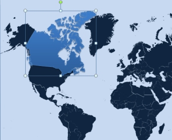
you don’t need to select each of these freeforms to stylize. Just point to Canada and all the freeforms are selected at once. Now you stylize it with just a single click, yes hundreds of freeforms. You can review Canada in the image on the right, all the individual freeforms are selected and stylized by single point and click. The vector freeforms can be stylized with fill, outline, gradient or any custom image fill style.
Import in Excel and Word with full freeform country names. Now these powerpoint editable slides can be imported into Excel and Word with all names of freeforms intact. So anything that you can do in Presentation, you can simply replicate in Excel or Word. There could be some issues with versions of Word lower than 2010, however Excel 2007 has been found to accept these freeform without any problems with all the names.
These amazing slides which can make a difference in your presentations, brochures and Excel reports are available in three amazing packages:-
- 16:9 and 4:3 Presentation Formats with Names Slides and Continent Slide, the complete and best package for only $149.95. Buy securely from Gumroad.
- 16:9 Presentation Format with Names Slides and Continent Slide, best for corporate presentations for only $99.95. Buy securely from Gumroad.
- 4:3 Presentation Format with Names Slides and Continent Slide, best for student and small company presentations for only $99.95. Buy securely from Gumroad.
All the map slides of the world countries and world continents in accurate details in two viewing formats, a package worth hundreds of dollars is available for only $149.95 only. You can use it even as a background.
